| Site Status: | Closed until further notice due to obstructions on launch and no beach access. |
| Site Name: | Point Prim |
| Location: | Point Prim |
| Province: | Prince Edward Island |
| Suitable for Hang Gliding: | Yes |
| Suitable for Paragliding: | Yes |
| Regulating Body: | HPAAC |
| Site Regulation: | |
| HPAC Rating: | Novice |
| Type of Site: | Coastal |
| Type of Flying: | Ridge |
| XC Potential: | Out and back |
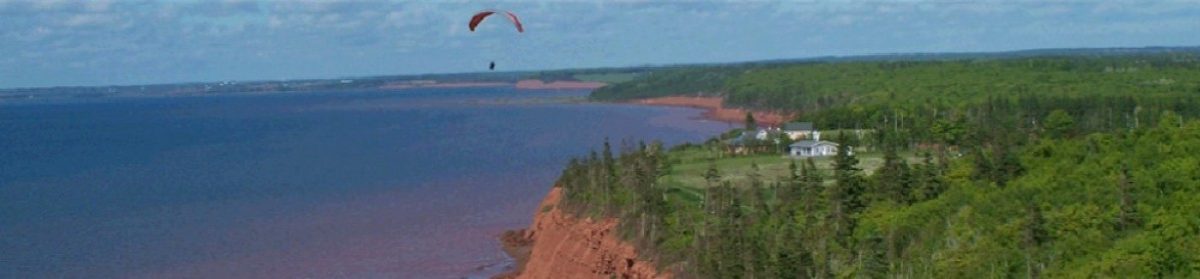
| Description of Site: | The site consists of approximately 7 kilometres of cliff and treed banks facing the Northumberland Straight and a large bay. Cliff height averages from 40-90′. |
| Direction of Launch: | NNW – N – NNE |
| Launch Elevation: | 80′ asl |
| Launch GPS Location: | 46.0729, -62.97255 |
| Launch Description: | PG –Launch and Set-up area descendes slightly to cliff. Approx 60 ft wide by 200 ft long. Low spruce trees either side of grassed launch area. Adjacent land owners are both happy for HG and PG visitors. If owners are in vicinity it would be prudent to make them aware of your flying activities. HG – As above, except set-up area recommended to right of launch behind treed area. Launch is a gradual slope that has been flattened and groomed to allow for running / foot launch take-off. For stronger conditions a wire-launch may be necessary. |
| Launch Site Rating: | |
| Transportation: | 25 kms from Charlottetown, Prince Edward Island.. Take Transcanada Highway East of Charlottetown towards Wood Islands Ferry. 2 kilometres after the Gas Station in Eldon turn right onto Point Prim Road. After 5tkms take a right onto a Dirt Road signposted, “Shipwreck Shore Road”. Park in between two properties near the trees. |
| Specific Hazards: | |
| Tips and Hints: | |
| Landing Zone Elevation: | |
| Landing Zone GPS: | |
| LZ Description: | Top Landing. PG & HG Landing area to right of launch past the two cottages where there is open land up to the trees. Beware of potential rotor from cliff, suggest HG’s land further back from cliff face. Beach can only be landed at low tide (below 1.0 meters) and due to sheer cliff height, access off the beach would mean a 3 km hike out to the west.NOTE: Until further notice, top landing is the only reasonable option as access to/from the site from the beach has been cut off due to the loss of the stairs that once provided access. Land owners have indicated that the stairs will be replaced at some point in the future. |
| LZ Site Rating: | |
| Transportation: | |
| Specific Hazards: | Beach. Caution – Dependant on Tides. Recommend that launching and flying take place when tides are below 1 metre (1.0 > ).
For current wind and tide forecast consult https://www.windfinder.com/forecast/point_prim Rotor behind short trees at launch, behind trees at cliff edge and behind cottages. Power lines are located 50-60m back from launch running parallel to shoreline. |
| Tips and Hints: | |
| Site Fee: | |
| Local Contact 1: | Chris Jette 902-675-3421 Cell: 902-940-0357 chris@a360.ca |
| Local Contact 2: | Brendon McKenna 902-892-0050 Cell:902-314-5125 |
| Seasonal Flying Potential: | 0=None, 1=Rare, 2=Low, 3=Good, 4=Excellent |
| Spring: | 3 |
| Summer: | 4 |
| Fall: | 3 |
| Winter: | 1 |
| Recommended Ratings | |
| Mild Conditions: | Novice |
| Moderate Conditions: | Novice |
| Strong Conditions: | Intermediate |
| Special Skills Required: | |
| Other Notes: | ** Note ** Please keep off new grassed area next to Log Home recently built to the left of launch.
NOTE: Until further notice, top landing is the only reasonable option as access to/from the site from the beach has been cut off due to the loss of the stairs that once provided access. Land owners have indicated that the stairs will be replaced at some point in the future. For current wind and tide forecast consult https://www.windfinder.com/forecast/point_prim |
| Radio Frequency: | HPAAC: 173.640 Mhz |
| Reviewed: | May 29, 2012 |